-
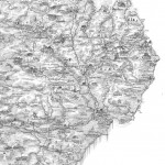
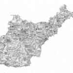
- The Borders
-
- East Anglia
-
- Lake District
-
- The North-West
-
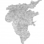
- The North West
-
- The North-East
-

- The North-East
-
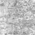
- The South-West
-
- The South-West
-
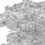
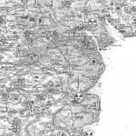
- The South-East
-
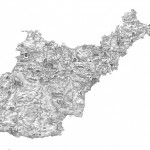
- Albion
-
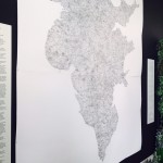
- Albion in situ at the Royal Geographical Society
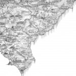
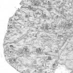
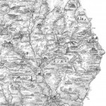
From the very beginning, an important facet of the project was the creation of a new map inspired by Hole’s cartographic vision. Following suggestions by a number of different experts, we contacted artist and map maker Stephen Walter, who went onto to produce a vast new mythic map of England and Wales: Albion (263.7 x 231.1 cm; Graphite on Paper).
Stephen writes about the commission:
“My maps are investigations into obsessive drawing techniques, semiotics, the glory of cartography, and where Landscape is seen as a receptacle for meaning. Each work is an intricate world in itself – a tangle of words, symbols and drawn elements where cultural residues inhabit certain locations.
In 2014, I was invited by Flash of Splendour Arts to consider a response to Michael Drayton’s Poly-Olbion – his epic 17th century topographical poem. I had been thinking of creating a map that delved into the folklores and legends of Britain for some time. This idea had persisted and the offer of this commission provided an opportunity to investigate these ideas further.
Drayton’s text, as if floating through the air on a lingual journey, weaving from one place the next, is a celebration of the landscape, its legends and its features. It pleasures in the many stories and myths that have accumulated over time, attaching themselves to certain places. It is also a celebration of its names.
Another aspect that grabbed me at the time was that Drayton was in the end unable to include Scotland in his Poly-Olbion, as originally intended. It only covers England & Wales. Taking this on in the year of the Scottish independence vote, I thought it would be a curious notion to imagine Britain without a Scotland.
William Hole’s map illustrations of Poly-Olbion provided a visual guide and whilst occasionally dipping into the poem itself, it was at this initial stage when my project began to move away from these works and venture into my own research and interests.
My map entitled Albion is a celebration of the geography of England & Wales. It also takes inspiration from fantasy maps such as those from Tolkien’s Middle Earth and other antiquarian treasures. It is an investigation into the names and places attached to the many myths, legends and folktales of the nation, especially to those that mirror certain historical events that have been lost or have faded through time. In doing so, I would seek to create my own set of landmarks along the way, merging my affection for places of wonder with others past down through the ages. It is a folkloric map of England and Wales where the mundane and regular things have evaporated away.
Many of the ‘enchantments’ found on this map are not particularly based on my imaginings – they already exist here today, either as historical sites that are already open to visitors and those places increasingly explored by the curious. Others can be discovered through the many folklores of our nation.
Many of the weird and wonderful names on this map are still to be found on mainstream charts – the villages of Snodland (Kent), Temple Cloud (Somerset) and Blubber Houses (Yorkshire) are examples of these. Others names hint at the past such as the Isle of Avalon – meaning the ‘land of apples’; ‘Pig Hill’ denoting (Swine don) – Swindon; and Bodmin – formally known as ‘House of the Monks’. In some cases, the place names describe the landscape features around which they are built. The village of Weeting by the Fens is one of these. Others describe the flora and fauna found to frequent these places, while some point to their original or past usages. I treat these words and names like emblems from the past – the names themselves become landmarks.
Albion is a map of England & Wales shown upside-down from convention, as if viewed from across the Caledonian Orogeny in Scotland (formed some 520 million years ago when North Scotland merged with England and Wales, as the tectonic plates of the world moved again into the form that we now know today). Here, the Scottish boarder falls away at the bottom of the image – North-becomes-South.
Also landmarked, are some of the bazaar yearly customs found around the country – such as the Haxey Hood in Lincolnshire and the cheese rolling custom at Coopers Hill in Gloucestershire; as well as some of the oldest known Shrovetide football games in the world at Ashbourne and Alnwick.
I celebrate the music festivals of this land from the legendary Isle of White festivals of 1969-70, Glastonbury Fair and many of the contemporary ones that have sprung up all over the country – the act of gathering is important here.
Many historical and sacred sights sites are shown, such as Stone Henge, Stanton Drew, Wood Henge, Avebury and Silbury Hill, many of which are still clouded in mystery.
Numerous sites associated with the legends of ‘King’ Arthur are pinpointed, such as Cadbury Castle (Somerset) or ‘Camelot’ and Tintagel (Cornwall). Dinas Emrys (Snowdonia) is attached to the rise of the legendary Merlin (Mwelrin) and where the battle between the Red and White dragons occurred. Ancient trees are landmarked in their positions; pre-Roman Solstice navigational routes are implied.
In delving into this territory, it would have been easy to find myself on unstable ground. I have tried to hold back from many of the myths that were deemed too localized in nature, as well as the more fanciful dragons, fairies and ghost stories that circulate in folklore. However, some have inevitably entered into the fray – such as the famous ‘Brown Lady’ of Rainham Hall (Norfolk), which is probably the most famous photograph of a supposed ghost in the country. Certain well-known bogeymen get a look in. So do others including black dog legends. The phenomena of small flickering lights over marshy ground (caused by self igniting gases from decaying matter – giving rise to names such as Punket, Jack o’ Lantern and Will o’ the Wisp also get a look. These tales – whether real or imagined, do hold a curious spell over the imagination. They have spread throughout the nation either in reaction to strange natural phenomena, or as tales told by parents in warning to their children against the dangers of wondering out alone at night in places still semi-wild. Whitby becomes ‘Dracula’s Landing’ and Dartmoor ‘Grimpen Mire’, in celebration of an alternative, gothic nation. Nuclear power stations, motorways and some of the major coal burning stations are also landmarked.
I include a few inventions and characteristics of my own in response to contemporary life but essentially it is a map that stands for a re-enchantment of place and a fascination with the landscape that is the receptacle for all our lives, and a testament to those that have survived the test of time.
The undulating shading on the map mirrors the relief of the land and the rivers are once again seen as veins through the country, hinting at their previous function as trade routes and highways where stories and interactions circulated. As we look to preserve the many eco-systems that exist in our country, these rivers will once again be of importance in the future.
Through contemplation, in relation to the landscape and our culture – I hope the names on this map will hold great meaning and point towards the vast mystery of our language and how it has forms and changed over time. These etymologies are seen here as old things that form and enter-weave with the lower layers of our national document – embedded within the land and the water that contains us. These chthonic elements that exist somewhere in our language begin to seep upwards again to the surface, as I doff my cap to such writers as Robert Macfarlane, the great map makers of the past such as Abraham Ortilius and the rich traditions of Landscape art.
I leave you with a set of words that are currently on the map, which will hopefully point to its nature:
Ravens Gap
Sheerness
Great Ooze
The grave of Cartigern
Chaucer’s Road
Snodland
The Gleaning Fields
Walland Rye
Goatwick Airport
Village of Fools
Sweet Fanny Adams
Luggershall
Adam’s Grave
The Battle of the Beanfield
& The Henge once free…
Temple Cloud
The Isle of Avalon
Seething Wells
Place by the Forked River
Tar
Barrel | Iska
Shebbear poles
Tintagel
Brown Willy
Jamaica Inn
Grimpen Mire
Resugga Castle
Wassailers | Knockers
Midsummer Beacon
St Michael’s
Botallack & Carn Boel Lands End…
Stephen Walter, September 2015
A limited edition of 50 Fine Art Prints are to be published by TAG Fine Arts and will
be available for sale later in the year: www.tagfinearts.com
In addition to these, five prints will enter the art collections of:
University of Exeter,
The Royal Geographical Society (with the Institute of British Geographers),
Flash of Splendour
English Folk Dance and Song Society at Cecil Sharp House.